Why in news?
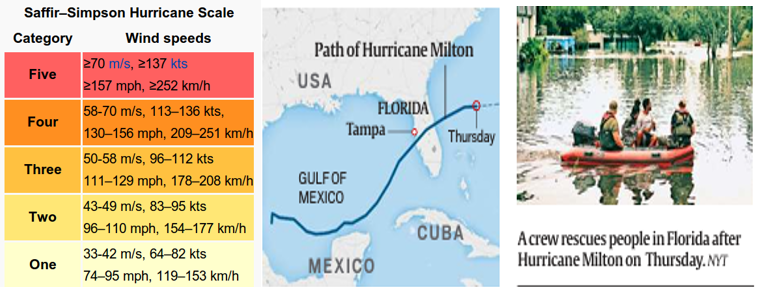
HURRICANE MILTON, which made landfall near the city of Siesta Key in Florida on Wednesday night, triggered intense rainfall, flooding, tornadoes, storm surge,and strong winds in the area.
- The storm killed at least 12 people, most in the eastern part of Florida, destroyed homes, knocked out power to more than 3 million customers, flooded barrier.
What was unusual about Milton?
- Milton exploded from a Category 1 storm (they bring winds of 119 to 153 kmph) to a fierce Category 5 storm (they have winds of 252 kmph or higher) over the course of 12 hours between October 6 and October 7 morning.
- By afternoon, it had sustained winds of a whopping 285 kmph, becoming one of the strongest hurricanes ever recorded in the Atlantic.
- A storm is said to undergo rapid intensification if its maximum sustained winds spike by around 56 kmph,
- Extreme rapid intensification takes place when wind speeds increase by 93 kmph.
- Milton’s maximum sustained winds spiked by more than 145 kmph in a day
- It was also rare that Milton formed in the Gulf of Mexico, which is connected to the Atlantic ocean by the Straits of Florida and made landfall on the Western coast of Florida
- most crucial factor behind Milton’s intensification were the remarkably high sea surface temperatures in the western Gulf of storms has become more common.
- There are not really any hurricanes on record that have done this and made landfall at a Category 3 + status.

Why was Milton an unusual storm?
- The most crucial factor behind Milton’s intensification were the remarkably high sea surface temperatures in the western Gulf of Mexico. The day Milton became a Category 5 storm, sea-surface temperatures reached nearly 31 degree Celsius, well above the 26 degree Celsius needed for hurricanes to develop
- Heat stored in oceans is a key ingredient in the rapid or extreme rapid intensification of hurricanes
- “Put simply, hotter water evaporates more readily, and rising columns of warm, moist air from that evaporation fuel rapid intensification
Reasons for intensification of Milton:
- Global warming: The American Meteorological Society (BAMS), predicted that as the planet gets warmer hurricanes’ rapid intensification just before landfall was likely to become “increasingly frequent and severe”.
- Unprecedented temperatures are primarily due to climate change.
- As the world continues to emit greenhouse gases, more heat is getting trapped in the atmosphere, a significant amount of which is absorbed by oceans.
- Global mean sea surface temperature has gone up by close to 0.9 degree Celsius since 1850, and around 0.6 degree Celsius over the last four decades.
- High Humidity: Another reason for Milton’s severe intensity was the high humidity of the atmosphere.
- The atmosphere can hold 7% more moisture fore very degree-Celsius increase in temperature.
- The increased moisture levels make storms more dangerous, leading to higher pre capitation intensity, duration and/or frequency.
- Lack of wind shear was also a factor. Wind shear is a change in wind speed and direction, and if it is strong enough, it can disrupt hurricanes.
- In Milton’s case, this did not happen. “All of that combined is making the storm more efficient at using the energy available.

 MPSC राज्य सेवा – 2025
